|
| |
Click on a parish to change parishes. |
| |
|
| |
|
| |
|
| |
|
| |
|
| |
PARISH PLANNING BASELINE |
|
|
|
|
| |
|
| |
| |
| |
|
| |
|
| |
 |
|
|
 |
East Baton Rouge Parish
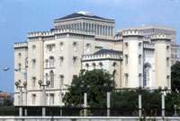
Louisiana’s capital city has matured and flourished in more than 200 years since establishment on the first high bluff of the Mississippi River. With cultural attractions, a diversified economy and historical sites such as Huey Long’s 1932 “new” Capitol, Baton Rouge is a metropolitan center along the Gulf Coast. Chemical and refining industries have contributed to the stable economy since Standard Oil built on the river bluff in 1909. Today, outlying parts of the parish offer rural charm, while the city remains a regional center for shopping and dining.
Just after the hurricanes, Baton Rouge gained respect as a primary staging area for the nation’s worst natural catastrophe. Its population briefly doubled and has since stabilized at nearly one-fourth larger than before the storms. Will displaced people stay or return to their old homes? How will the community deal with an increase in population and demand for services? Challenging questions like these are on the lips of every resident, and leaders are grappling with growth issues few American cities have faced.
|
|
 |
- The parish was named for a Native American border marker of animal skins strapped to a tree or pole, spotted on the banks of the Mississippi by explorer Pierre le Moyne, Sieur d'Iberville in 1699. In his diary, he recorded a "reddened maypole." In French, red stick is baton rouge.
- East Baton Rouge was successively ruled by the French, British and Spanish.
- The first American army to have African American officers was the confederate Louisiana Native Guards. The Corps d’Afrique at Port Hudson was sworn into office September 27, 1862.
- The Baton Rouge flag features a field of crimson representing the great Indian nations that once inhabited the area.
- East Baton Rouge Parish has 455 sq. miles in land area and a population density of 906.1 per square mile. In the last three decades of the 1900s, its population grew by 44.8%.
- The average household size is 2.55 persons compared to an average family size of 3.14 persons.
- In 2004, health care and social assistance was the largest of 20 major sectors. It had an average wage per job of $33,416. Per capita income grew by 15.5% between 1993 and 2003 (adjusted for inflation).
- The parish seat is Baton Rouge.
- Larger communities are Baker, Baton Rouge, Central, Greenwell Springs, Port Hudson, Pride, Scotlandville and Zachary.
- Pre-storm, the population was 413,000.
- Significant economic interests are public administration (state, local government and schools), oil refining, chemical firms, Louisiana State University, Southern University, retail and warehousing, metal fabrication and other light industries.
- The Louisiana state capitol in Baton Rouge is the tallest capitol in the nation at 450 feet and 34 floors. It was completed in only two years at a cost of $5 million and dedicated in 1932.
|
|
|